
Air Quality & Health Risks
Check Air quality with MassDEP
![]()
New England Continues to Experience Poor Air Quality due to Smoke from Canadian Wildfires on Thursday June 29, 2023
June 28, 2023
Contact Information
Jo Anne Kittrell (kittrell.joanne@epa.gov)
(617) 918-1822
BOSTON (June 29, 2023) – New England state air quality forecasters are predicting elevated concentrations of fine particle air pollution due to wildfires in Quebec and Northern Ontario. The primary concern is high concentrations of fine particle air pollution that is unhealthy, especially for sensitive groups such as people with respiratory disease, the elderly, or people with compromised health.
Areas that are forecasted to exceed the Federal air quality standard for 24-hour particle pollution level concentrations are:
Western Massachusetts, Rhode Island, and Vermont
EPA encourages people to check their Air Quality Index (AQI) throughout the day to be aware of their local air quality. Hazy skies, reduced visibility, and the odor of burning wood is likely as the smoke plumes are transported over the region. During the times that significant smoke is in your area, it is recommended that people with pre-existing medical conditions remain indoors with windows closed while circulating indoor air with a fan or air conditioner. For more tips, see https://www.airnow.gov/wildfires/when-smoke-is-in-the-air/.
Exposure to elevated fine particle pollution levels can affect both your lungs and heart which may cause breathing problems, aggravate asthma, and other pre-existing lung diseases. When particulate matter levels are elevated, people should refrain from strenuous outdoor activity, especially sensitive populations such as children and adults with respiratory problems.
Everyone can take steps to keep air emissions down during air quality advisory days. Due to impacts from climate change, these kinds of air quality events are predicted to increase in frequency. Communities already vulnerable and overburdened will also be impacted by these kinds of events.
Stay up to date on current air quality and forecasts near you through the AirNow app, available for free on the Apple App Store and Google Play Store. You also can use the app to check the AirNow Fire and Smoke Map. EPA and the U.S. Forest Service developed the map to give the public information on fire locations, smoke plumes, near real-time air quality and actions to take to protect your health -- all in one place. The map is available at https://fire.airnow.gov, or by tapping the Smoke icon in the AirNow app. It includes data from hundreds of air quality monitors provided by state and local air quality agencies, along with crowd-sourced data from air quality sensors.
More information and Resources:
Real-time ozone data and air quality forecasts New England Air Quality Index
National real-time air quality data (free iPhone and Android apps) AirNow
Air Quality Alerts EnviroFlash
June 8, 2023
EPA Statement on Wildfire Smoke
June 8, 2023
Contact Information
EPA Press Office (press@epa.gov)
The U.S. Environmental Protection Agency (EPA) collects data from hundreds of air quality monitors provided by state, local and Tribal air quality agencies, along with crowd-sourced data from air quality sensors. This data underpins the AirNow Fire and Smoke Map, which EPA developed in partnership with the U.S. Forest Service. This tool provides current air quality information, smoke plume locations and recommended actions to take to protect your health – all in one place. The map is available in English and Spanish. In addition to being accessible through EPA’s webpage, the map also is available through the AirNow smartphone app. EPA is promoting these reources through digital channels (see tweet thread from the EPA account, and this thread from the Administrator, and this thread from the AirNow account. EPA has more detailed information resources tailored to specific audiences.[1] EPA will continue to maintain close contact with our state and local partners throughout the region. EPA also provided the statement below to a network of interested reporters.
EPA June 7 Desk Statement
A weather system carries smoke from wildfires in Canada hundreds of miles into the U.S., pushing air quality into the unhealthy or worse categories in areas from the mid-Atlantic through the Northeast and parts of the Upper Great Lakes. EPA encourages people living in these areas to check their Air Quality Index (AQI) throughout the day to see their local air quality and steps to take to reduce smoke exposure and protect their health. Pay attention to any health symptoms if you have asthma, COPD, heart disease, or are pregnant. Get medical help if you need it.
Smoke can cause air quality to change rapidly. Stay up to date on current air quality and forecasts near you through the AirNow app, available for free on the Apple App Store and Google Play Store. You also can use the app to check the AirNow Fire and Smoke Map. EPA and the U.S. Forest Service developed the map to give the public information on fire locations, smoke plumes, near real-time air quality and actions to take to protect your health -- all in one place. The map is available at the AirNow Fire and Smoke Map webpage, or by tapping the Smoke icon in the AirNow app. It includes data from hundreds of air quality monitors provided by state and local air quality agencies, along with crowd-sourced data from air quality sensors.
Most healthy adults and children will recover quickly from smoke exposure and will not have long-lasting health effects. But people with chronic diseases, such as asthma, other lung disease, or cardiovascular disease are at greater risk of experiencing more severe health effects. Children, pregnant people, and people over 65 also are more vulnerable to health effects from smoke exposure Limit your outdoor exercise when it is smoky or choose lower-intensity activities to reduce your smoke exposure. When indoors, take steps to keep your indoor air cool and clean. For more tips, see AirNow’s When Smoke is in the Air webpage.
Larger and more intense wildfires are creating the potential for greater smoke production and chronic exposures in the U.S., particularly in the West. Wildfires increase air pollution in surrounding areas and can affect regional air quality. If you have to be outdoors when wildfire smoke is in the air, an N-95 mask can help reduce the smoke you breathe in and potential health risks.
State, local and tribal governments work closely with EPA, the Forest Service, and other departments to maintain a strong monitoring network to help inform the public about local air quality conditions and what steps to take to protect themselves from air pollution and wildfire smoke. This partnership is what makes AirNow.gov work.
According to the National Weather Service, "poor air quality can be hazardous." Here's what to look out for.
Headaches, irritation and fatigue
Among the most minor of symptoms when it comes to health effects of poor air quality are headaches, sinus and eye irritation, and fatigue. Even though they are not as severe as some other potential effects, they could cause significant discomfort or worsen other impacts.
"If you look at your car this morning and it's been parked outside and there's a fine layer of soot over your car, well, it's often gonna be inside your lung, inside your chest," Lahita said. "And that is a big problem. A lot of people can't tolerate it and will be coughing and sneezing all day."
Respiratory issues
Those who have pre-existing respiratory issues, including asthma, are more susceptible to the impacts of wildfire-fueled poor air quality. Difficulty breathing, asthma attacks, irritated throat, bronchitis, reduced lung function, coughing and chest pains are all health effects of wildfire smoke and bad air quality. And according to the EPA, it often leads to an "increased risk" of emergency room visits.
You don't have to be in direct line with the wildfires to have those impacts.
"Pollution from wildfire smoke can rise up to 14 miles into the air and then is carried with wind currents which is why it affects everyone," Cleveland Clinic pulmonologist Neha Solanki said in 2021. "So even if you don't live directly near wildfires, you're still exposed to all of that toxic pollution."
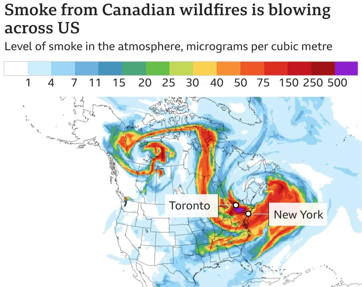
More than 9.3 million acres have been "charred" by dozens of ongoing fires in Canada, The Weather Channel's Stephanie Abrams said on "CBS Mornings" Wednesday. And the smoke that has since drifted to the U.S. "could last for a while."
"There's going to be thick smoke pollution at least through Saturday, especially in the Northeast," she said.
Cardiovascular issues
Similar to respiratory issues, pre-existing cardiovascular problems also pose a problem when it comes to air quality. Heart failure, heart attacks and strokes are all possible when exposed to poor air quality, even for short amounts of time. Chronic heart issues, such as congestive heart failure and high blood pressure, have been linked to premature death.
Weakened immune system
According to the Cleveland Clinic, there is evidence that smoke inhalation weakens the immune system.
"We breathe in smoke and it gets into our bloodstream," Dr. Solanki said. "Then the particles stick to a location in our body and the immune system activates and can create an inflammatory response."
In 2021, a Harvard study found that thousands of COVID cases and deaths across California, Oregon and Washington could be linked to the increases in air pollution caused by wildfire smoke.
How bad is the air quality?
On Wednesday, New York City, which typically has a "good" air score on the Air Quality Index, ended up with one of the highest amounts of air pollution across tracked global cities at a level considered "unhealthy" by national standards.
Much of the Northeast was under that same "unhealthy" level as of Wednesday morning, according to federal tracking, with some areas – including portions of New York, Pennsylvania, New Jersey, Delaware and Maryland hitting "very unhealthy" levels, meaning the general population, not just sensitive groups, is susceptible to health impacts.
-information obtain from The EPA the national weather service, CBS and The BBC
**photo from the BBC**